Union City Tornado Makes History
By Rachel Shortt

As the devastating tornado tore through the small town of Union City, Okla., on May 24, 1973, no one knew the tremendous impact it would have on the development of weather radar. Researchers from the NOAA National Severe Storms Laboratory now look back on that day as a significant event in the history of severe weather research and forecasting.
"We weren't expecting much that day, just storms, but not necessarily tornadoes," said Don Burgess, former NSSL researcher and division chief and now research meteorologist with the Cooperative Institute for Mesoscale Meteorological Studies at the University of Oklahoma. "We had the facility here at NSSL ready. As storms developed less than 100 miles away, the Storm Intercept Teams were located in the vicinity of the developing tornado, we were able to get the entire life cycle of a tornado documented for the first time ever."
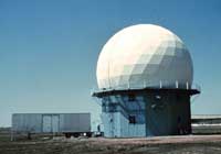
Rodger Brown, NSSL research meteorologist, worked that day in the newly built and experimental Norman Doppler Radar to collect the data. Because they had no real-time displays, they relied on Les Lemon, former NSSL researcher, who was monitoring the surveillance radar they had at the time to indicate the sector Rodger needed to look at in the storm in order to collect the data. Since the storm was continually moving, Rodger and his team needed constant updates to determine what sector they should scan to actually capture the storm.
Data were recorded on magnetic tape. It was a few months later before the tapes were processed on a computer, and the researchers could first see the data.
"We kind of take for granted that now we have fancy real-time color displays that process lots of data for Doppler Radar, but we didn't have those kinds of displays in 1973," Burgess said. "All this was very new, and the displays didn't come along until a few years later."
Since the Union City tornado happened in the early afternoon, Burgess and Brown were able to go up that same day and do an aerial damage survey.
"I think that's the first time we realized the extent and how devastating the tornado was," Brown said.
Researchers continued their damage surveys in Union City for weeks afterwards, collecting additional and very precise data.
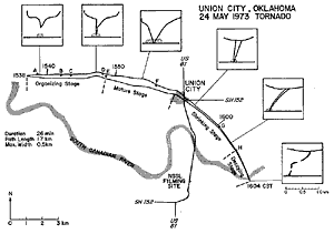
The Union City tornado provided researchers their first opportunity to see the entire life cycle of a tornado. In addition to clearly seeing its evolution, the NSSL team discovered the tornado vortex extended some distance up into the storm.
Impact of the Union City tornado on tornado forecasting has been very significant. For the first time, researchers discovered that the circulation appeared aloft before the tornado descended to the ground, and they knew they had a very good potential warning device, Brown said. Researchers have since learned not all tornadoes form that way, but the radar signature is still helpful in most situations.
Doppler radar's ability to "see" the signature of a developing tornado was a major reason the national network of NEXRAD Doppler radars was formed in 1988. These radars have been extremely successful in helping National Weather Service forecasters increase the lead time for tornadoes and ultimately save lives. The development of Doppler weather radar has had a very big impact on the way the National Weather Service operates and their success in issuing warnings for tornadoes.