
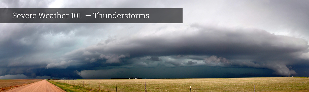
Severe Weather 101
Frequently Asked Questions About Thunderstorms
- What is a supercell?
- A supercell is an often-dangerous thunderstorm with a very organized internal structure including a rotating updraft that allows it to keep going for up to several hours. Supercells are capable of producing severe weather including high winds, large hail, and strong tornadoes. They are most frequently isolated and often develop in the warm air ahead of a squall line. A supercell also usually forms in an environment with strong vertical wind shear that causes the updraft to begin rotating.
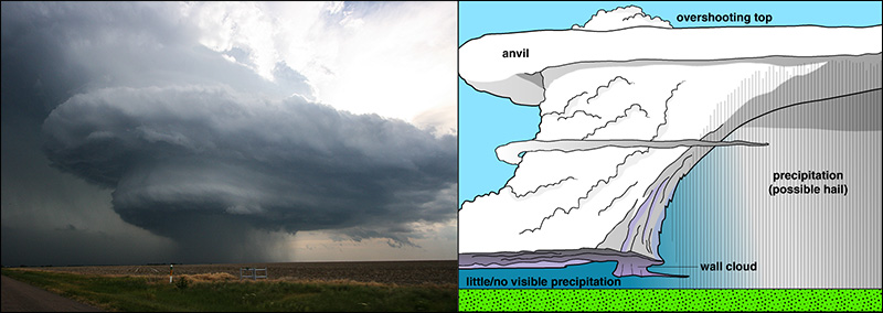
Supercell [+]
- Why are there thunderstorms?
- Thunderstorms are a great way for the atmosphere to release energy. When warm moist air meets colder drier air, the warm air rises, the water vapor condenses in the air, and forms a cloud. As the water vapor condenses it releases heat, which is a form of energy. A large amount of the thunderstorm's energy comes from the condensation process that forms the thunderstorm clouds. As the thunderstorm progresses, eventually the rain cools the entire process down and the energy is gone.
Thunderstorms also help keep the Earth in electrical balance. The Earth's surface and the atmosphere conduct electricity easily – the Earth is charged negatively and the atmosphere, positively. There is always a steady current of electrons flowing upwards from the entire surface of the earth. Thunderstorms help transfer the negative charges back to earth (lightning is generally negatively charged). Without thunderstorms and lightning, the earth-atmosphere electrical balance would disappear in five minutes! We aren't really sure what would happen if this balance wasn't maintained. But thunderstorms are not the only way the atmosphere conducts electricity – the solar wind and ionospheric wind play a role too.
What we do: More than 100 researchers from NOAA, NSSL and 29 other organizations collaborated on a field project to discover how thunderstorms act like elevators, taking pollution, electrical activity and water-rich air from the surface and lofting it straight up into the upper troposphere. Learn more about NSSL field projects→ - Where can I find out information about a storm?
- Several places will have storm information. The local National Weather Service office in the area of the storm conducts damage surveys from severe weather events. The Storm Prediction Center documents storm reports, but the official designation is left up to the local National Weather Service Office. The NOAA Centers for Environmental Information (formerly NCDC) maintains the official national database for weather.
- What direction does the wind come from during a thunderstorm?
- There is no one direction the wind comes from when thunderstorms or tornadoes occur. Where warm moist air is forced to rise by hills, mountains, or areas where warm/cold or wet/dry air bump together, thunderstorms can form. The surface direction of wind varies depending on your location (northern/southern hemisphere, and even coastal/plains/mountains), and what weather patterns usually affect the area.
- Is there a specific thunderstorm season?
- Consider contacting your local National Weather Service Forecast Office because they will be more in tune with your local climatology.
- In addition to actually seeing them, how are thunderstorms detected?
- We can see thunderstorms with a variety of tools. Radars let us see where rain and hail are located in the storm. Doppler radars also let us see how the wind is blowing within and near the storm. Some features of thunderstorms, such as the anvil that spreads out at the top of the storm, can be seen from satellites.
- Why are severe thunderstorms so dangerous?
- Rainfall from thunderstorms causes flash flooding, killing more people each year than hurricanes, tornadoes or lightning. Lightning is responsible for many fires around the world each year, and cause fatalities. Hail up to the size of softballs damages cars and windows, and kills wildlife caught out in the open. Strong (up to more than 120 mph) straight-line winds associated with thunderstorms knock down trees, power lines and mobile homes. Tornadoes (with winds up to about 300 mph) can destroy all but the best-built man-made structures.
- Why does it rain on one side of the street and not the other?
- The answer to this question is that most things have a beginning and an end. The rain has to start somewhere and end somewhere. Sometimes it happens to start on one side of the street, and moves away, never getting the other side wet.
- Why doesn't the west coast of the U.S. experience more thunderstorms?
- There is less convection on the west coast in part because of the cool water temperatures off shore in the Pacific Ocean. That impacts the temperature of air that moves inland, making it generally more stable and less convective; convection = thunderstorms). To get thunder you need strong updrafts (convection), which means rapidly falling temperatures with height (vertically) in the atmosphere.
- Are there winter thunderstorms?
- Winter thunderstorms do happen, but they are rare because the air is more stable. Strong updrafts cannot form because the surface temperatures during the winter are colder.
- Why does the sky sometimes turn orange after a thunderstorm?
- Most thunderstorms occur in the late afternoon. By this time of day, the sun is beginning to set. The orange hue is caused by the same process that causes the vivid colors at sunsets. Shorter wavelengths of light (blue) are scattered quickly, leaving only the yellow-orange-red end of the spectrum.
- What is a derecho?
- A derecho (pronounced similar to “deh-REY-cho” in English) is a widespread, long-lived wind storm that is associated with a band of rapidly moving showers or thunderstorms. Although a derecho can produce destruction similar to that of tornadoes, the damage typically is directed in one direction along a relatively straight swath. As a result, the term “straight-line wind damage” sometimes is used to describe derecho damage. By definition, if the wind damage swath extends more than 240 miles (about 400 kilometers) and includes wind gusts of at least 58 mph (93 km/h) or greater along most of its length, then the event may be classified as a derecho.
- Do all thunderstorms have hail?
- Most thunderstorms have hail, but not all thunderstorms produce hail at the ground. Temperatures at the upper levels of a thunderstorm are well below freezing, allowing for the development of hail, but sometimes it melts before reaching the surface of the earth.
- What is SKYWARN?
- SKYWARN is a National Weather program that is run by and coordinated by the NWS. It was a concept developed in the early 1970's that was intended to promote a cooperative effort between the National Weather Service and its communities. The emphasis of the effort is often focused on the storm spotter, a volunteer who takes a position near their community and reports wind gusts, hail size, rainfall, and cloud formations that could signal a developing tornado. YOU can be trained to be a SKYWARN spotter. Visit the NWS SKYWARN® website to find a link to local SKYWARN groups. If your area is not listed, contact your local National Weather Service Office.
- Do storms split up and/or dissipate after crossing a river?
- Unfortunately, there is no proof that storms split or dissipate after they cross rivers...they can, and do, but not in a way that would indicate a pattern. There is no documented evidence that the effects of a river or lake, even a mile wide, has a significant effect on the dynamics of a thunderstorm. The scale of the river is very small when compared with the scale of a thunderstorm that extends five miles or more into the atmosphere and can range from tens of miles to hundreds of miles in diameter.
- Can you give me details on a particular hailstorm, thunderstorm or tornado which hit on a certain date? Or can you tell me about hail or wind damage for the last 20 years in a certain place?
- Unfortunately, no. We don't have the resources or staffing to fulfill every local weather information request we receive. However, the National Climatic Data Center does provide local weather event information, both in an interactive online website, and—for severe and extreme weather events—in a publication called Storm Data.
Also, go to weather.gov and enter in your location. It will take you to your local NOAA National Weather Service Forecast Office and you may contact them with your question. If you think the storm was severe, you might also check the Storm Prediction Center's Severe Weather Event Summaries page for severe weather storm reports.